One of the challenges of writing a travelogue almost two months after the elapsed travel is the loss of memory. During the elapsed period new events flood the brain and especially when this period coincides with the Festive season, the loss is even greater.
For the past four-five years, I have been on a few Himalayan treks and the addiction is such that the mountains keep calling to visit them time and again. This year, after the Chadar Trek, I had planned to do the Markha Valley trek (Ladakh) in September. And every traveler on the forum and everywhere will agree that the planning phase is certainly the most exciting phase of any travel and that period of ‘waiting’ for the actual travel to kick off, is a sweet pain that only the traveler can feel. Air tickets were booked and the usual training regime undertaken. But nature had other plans and that trek couldn’t materialize. The proverb “Man proposes, God disposes” couldn’t be more apt I felt.
I kept looking for some options. Constraints were many: Like treks in Uttarakhand were banned due to a High Court and the ones that were available were costlier ones. Plus end September is the time when most treks come to a close. But all of a sudden, checked the Trek The Himalayas website for “Fixed Departure Treks” and found that a Rupin Pass trek batch was available. Booked it almost instantly and departure date was fixed as 22nd Sept, 2018.
Geography and Trek Schedule
The Rupin Pass is a 15,250 feet high pass in the Himachal Pradesh in the Kinnaur District with the road head being at Sangla. The trek actually encompasses two states: It starts from a village called Dhaula in Uttarakhand and ends at Sangla in Himachal with five of the eight days being in Himachal Pradesh. Following is the planned itinerary. But in our case the Day One Trek was cancelled due to incessant rain and we were forced to combine Day One and Day Two in a single day.
So coming back to the trek.
Transit from Kolkata to Dhaula (Base Camp)
22-Sep-18 to 23-Sep-18
I had booked an Air India flight from Kolkata to Delhi around 1800 HRS in the evening. While boarding the aircraft I was surprised when I saw a Boeing 777-300 ER being the aircraft. Later came to know that the same plane is scheduled for a journey to New York! Nevertheless, the “upgrade” was pleasantly surprising and I spent the next couple of hours watching Vanilla Sky and munching onto the snacks. After reaching Delhi, I took the metro to New Delhi Railway station from where I boarded the Nanda Devi express to Dehra Dun.
The train was supposed to reach Dehra Dun at 0600 HRS on 23-Sep-18. However it was late and we managed to reach Dehra by 1100 HRS. The mode of transport from Dehra to Dhaula was a Tempo Traveller. It rained throughout the day – a rain that lasted 48 hours more. The gloomy weather didn’t lift the spirits and on top of the interrupted journey that started from 3 PM, it was a tiresome. We stopped mid-way for lunch. And once more for some very sweet tea in the evening. As dusk was falling, we saw a group of Bakrawalas who steadied their flock of sheep and goats through the rain towards a place of shelter. The ravaging river continued stormed beside the road, It grew narrower in width but its current had turned fiercer with every mile that it passed. As the sunlight went kaput, the hitherto good road turned worse and the bumpy ride continued till 1900 HRS when we finally reached Dhaula. A quick dinner later we huddled in different rooms of a homestay for the night after which we went to sleep. The rain continued, heavier with each passing hour.
But little did we know that it would impact our plans for the next day.
#Day 1 24-Sep-18: We stay put at Dhaula
When we woke up around 7 in morning, the rains continued to pour heavily. And it was quite chilly. Breakfast arrived. Paranthas and tea. We kept wondering how we would walk if the rain continues like the way it was pouring. But sometime later the rain ceased and everybody got busy packing their bags.
A funny incident happened next. The guide came up for a briefing session. “Is everybody ready?”, he asked as if questioning our readiness and with an urgency that we need to depart fast – since the rain had delayed our start. We said a resounding “Yes”. But imagine our surprise when he quips “Today we are not going to trek.” All of us were left aghast! The reason was a broken bridge that got washed away in the overnight rains.
The whole incident was depressing enough . But the homestay where we were housed, was beside the river and from the long and wide verandah we spent the whole day watching the fierce river cascading over the rocks. In all the time it continued to rain throughout. And helped by a running doses of tea, maggi and pakodas the day was spent. In the evening the rain stopped for good and we went on a hike to a nearby hill. We also got acquainted with ourselves. We were a 13 member team. Two of us were in exact mid-thirties, an uncle was close to sixty and the median population of the rest was 25.
As the night closed in, the clouds started to clear and by 10 o clock there was a clear moon high up in the sky and also some stars could be seen.
Due to the loss of the day it was decided that we will cover the distances of two days in one.
Day #2 25-Sep-18 Dhaula (5,100 ft) to Bawta (6,888 ft) (15 kms, 9 hours)
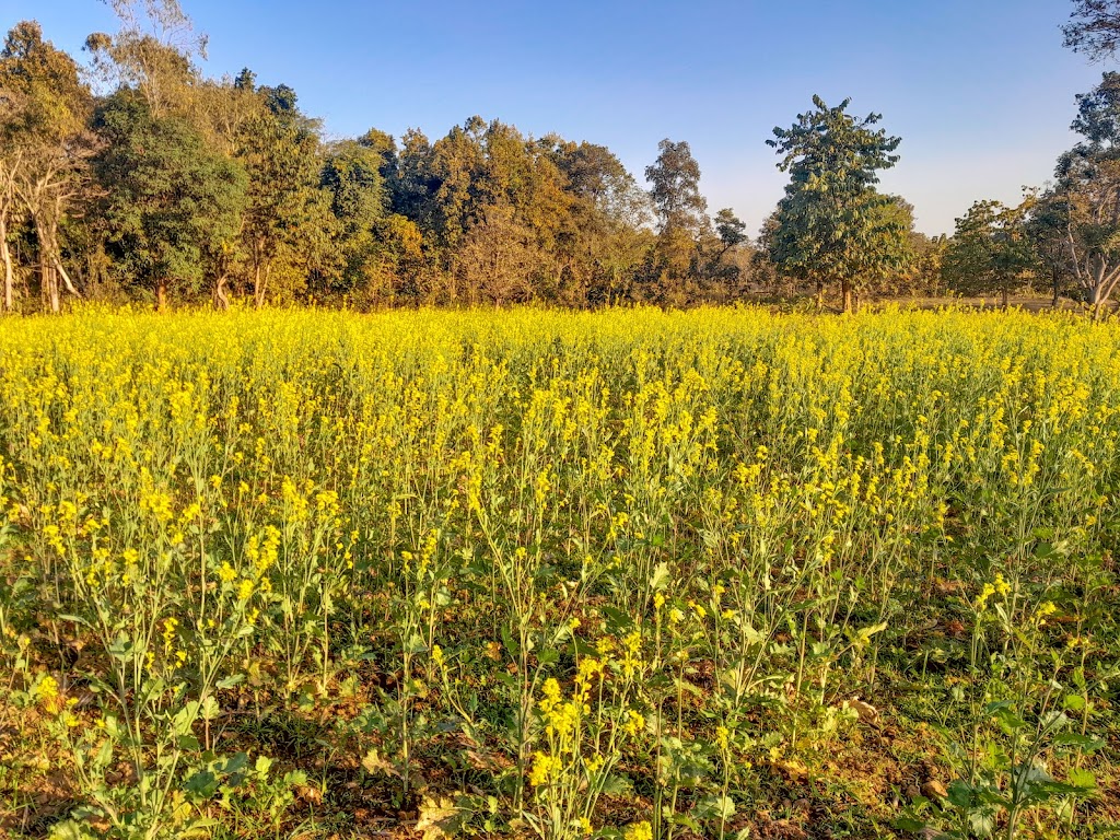
The rains had stopped and the beauty of post monsoon started to reveal in all the corners, trekking pathways, in the far hills…everywhere. The sky was a clean virgin blue. Everywhere the waterfalls were overflowing. Flowers had grown and the greenery was intense. And with the sun up, it was getting hot. Most of us were sweating in our T-shirts.
If one sees the net again in altitude, it will appear that the gradient is minimal. But the entire route has ups and down and that makes the walk difficult. Sometimes you go down as far as the river bed and at times you need to walk right up a 45 degree slope. We stopped at Sewa for our packed lunch of parantha and subzi. We were provided chocolates and toffees as refreshments which we munched all along. The sun was intense till 2 o clocked in the afternoon. But after that the sunrays got “lifted off” from the valleys and in the shadows it was getting chilly at times.
After the lunch break the walk got even more difficult as the slopes were higher. Finally after a long ordeal when most of us were tired beyond imagination we trudged in to our homestay where after a “physical conditioning” session in the courtyard we were offered hot tea. Since it wasn’t “that” cold and we were dirty, I took a bath. Evening was spent chitchatting and quick dinner. That night uncle was heavily tired and said that his knees were burning with pain.
The sky remained clear in the night. The homestay was located at the highest point of Bawta village and in the night we saw some lights lower down the hills slopes.The tiredness lulled most of us to sleep. A dog barked in the middle of the night when I woke up for a bathroom break. But rest was silent.
Day #3 Bawta (6,888 ft) to Jakha (8,700 ft) (5 kms, 4 hours)
The day was a short one and we were headed to Jakha– literally meaning “Hanging” village. After yesterday’s long walk most of us took sometime to prepare ourselves for the onslaught ahead. The distance, even though less, was quite steep. And the first hour that we started walking it was a steep climb all along. We stopped at the last decent shop to buy gloves, head gear, ponchos – which I hadn’t taken. We also stopped for tea. It was only an hour’s climb, but we couldn’t locate uncle.
Uncle, who was close to his sixties narrated an interesting story. Based on the initial conversation that I had, I felt that he was an experienced traveler. But later got to know that this trek was his first trek. When he was in his early thirties, he had heard about the Roop Kund trek from a close friend of his. Accordingly he read a lot about it. But family duties and work had kept him away from pursuing his passion. But now his son was established and daughter had already got a job and he had the time to pursue his passion. And he originally booked the Roop Kund trek, but with the recent high court order that banned treks on meadows in Uttarakhand, he was shifted to the Rupin Pass trek. And that is how he ended up with our batch. But where was uncle now, we wondered, as we all waited for him. A little while later, the guide came up and we came to know that uncle had descended. His trek was over.
All of us wonder that we will pursue our passion when we have time and money. But then we finally get both time and money, even though the zeal,the passion is there, but the energy isn’t there. Just like it happened in this case. A lesson learnt!
Steep hike through thick vegetation, forests, and streams under a bright blue sky brings us to Jakha. We are stationed at a homestay for the night. Again its bright and hot in the afternoon when we reach Jakha and sweating. We have lunch in the homestay and while away the afternoon. Dinner is quick again.
The next day we will go to Dhanderas Thatch – the meadows.
Day #4 Jakha (8,700 ft) to Dandreyash Thatch (11,680 ft) (11 kms, 8 hours)
The previous night we got a clear glimpse of the Milky Way. The next morning we depart at 8 in the morning in anticipation of a long day ahead. Till Jakha all loads were ferried by mule. But from Jakha onwards, mule tracks don’t exist and load is hauled by porters. For a, now 12 member team, the number of porters required is around thirty, if not more. The climb here is almost one vertical kilometer in a horizontal walk of eleven.
After a half an hour walk after Jakha, where the track has thinned and tall coniferous trees grow on the steep hill sides we come to a stop. The guide asks us to stick to the hill side as we hear the sound of bells and an incoming multitude. And then they come, the sheeps, that had gone to the high altitude pasture lands to graze. The sheeps funnel down the tracks in thousands. The shepherds whistle and force them to descend. We also see that the sheeps are guarded by dogs.
We start walking again and take period breaks. Sometime later the trekking path disappears into a cascading river bed, beside which we continue to walk. A few miles down, I get a shock. The bridge that was washed away 2-3 days back has come to haunt us. And instead of the bridge, now placed are three adjacent wooden planks each not more than 8 inches wide. There is no support and hurtling 15 feet below is the raging river where if you fall, chances for being alive is rare. I wish I could take a photograph. But those who have read my articles earlier would know my fear of height. And in these circumstances I took the guide’s hand and somehow scrapped through. After crossing the bridge we came to a sweet spot that was the last maggi stop on the route. Here we offloaded our bags and relaxed and had tea.
The next few miles were steep amidst thinning forest line. We soon came to a spot where the snowy mountains appeared for the first time. And a wide, flat valley opened up. Here, under the shade of a tree, beside a flowing stream we took our lunch. A cool wind was blowing through, wiping away the perspiration.
After sometime we saw the upper waterfall of the three stage Rupin waterfall. The terrain became rocky and trees had disappeared by then and only shrubs were there for company. But after walking further, with thick clouds that were gathering, the rocks disappeared and even though the route became steep, it was an undulating grass land. At the rear end the sun beamed through the dark clouds that threatened rain and on the other side, inclined, stood the Rupin Waterfall. Towards the right and left were low rising hills. We had reached the meadows.
But the campsite was further away and it took quite sometime to reach the campsite. Then due to communication trouble the porters arrived late. And by the time tents were pitched it was past 7 PM. Then it started to rain as we slept in a tent for the first time. We had dinner around 10 PM and then spent sometime taking night shots of the tents.
Day #5 Dandreyash Thatch (11,680 ft) to Upper Waterfall (13, 420 ft) (3.5 kms walk, 3.5 hours)
When your target or objective becomes visible, it makes the job easier for the trekker. The objective so to speak was visible i.e. climb the three stages of the Rupin waterfall and it was a 1700 feet climb overall: quite steep. In the morning the meadows were buzzing with activity. Trekkers preparing for the day, a horse or mule grazed at the grasses, a solitary flower bloomed. Camps were struck, breakfasts eaten and we started walking under the sun. But those who go to these mountains know that the weather can change in a few seconds.
As we started the climb, the blue skies were overtaken with dark clouds. At a resting point the entire Dandreyash Meadows appeared like a U shaped valley through the middle of which the Rupin river snaked through. We had climbed the first stage. For the next stage we had to cross the waterfall from one side to another. For that we had to open our shoes, put the camera inside the backpack and then step out into the bonechilling waters with deep currents. Again the guides from different teams helped by placing boulders and holding hands as we somehow managed to make our way.
Here we again came across a folk of sheep. When I had crossed the difficult stage and took my position at a vantage point, I saw how the sheeps crossed the current. The shepherds placed boulders and whistled towards the sheeps and these being trained in the mountain skirted across the currents and jumped over boulders and crossed.
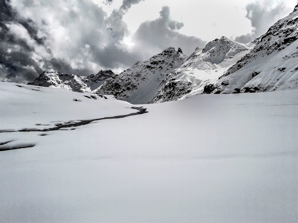
We reached the campsite in the afternoon and it had started raining by then. All around it was bleak and dull. We spent the afternoon by snoozing in the tent and sometime later the intensity of the rain changed or so we felt. In the evening, tea was served in the tents itself and when we opened the zipper we saw that the ground was covered in white. It has been snowing for the past 2-3 hours.
The snowfall continued till late in the night and to prevent collapse of the tent, we spent the night knocking the snow out. I checked the watch and it was around 2 AM in the night when the snowfall abated. The past night we hadn’t slept for a moment. And then I stepped out to take a bio break and the sky was clear. What ever cloud was there were racing against the full moon sky. The grassy floor was white with some patches that were still green. A mule kept calling the whole night. It was so pristine and Godly that is difficult to define the feeling one gets.
We received the wake up call at 4 AM. It was the pass crossing day and the most difficult day amongst all.
Day #6: Upper Waterfall (13, 120 ft) to Ronti Gad (13, 420 ft) via Rupin Pass (15,250 ft) Pass crossing day. 11 kms, 10 hours walk
Trekking companies advertise the pass crossing day as the “summit day” – how much relevant it is, I really don’t know. But we climb the pass today and in tht ze snow and cold it can get quite difficult. With groggy eyes and no sleep , the tea helped only slightly. But then with the torches we packed our bags and stepped out. Outside you wont need the torch because, like I said earlier, it was all white and flooded with the full moon. At a distance one could see the India Hikes team heading out with their series of head torches up a steep incline. But here we were who hadn’t even finished packing our bags. Hot maggi was served for breakfast.
One thing that I remember from the Goecha La trek is, on the summit day eat your breakfast properly. And even though having some maggi at 5 AM (we had whiled around an hour after waking up) is not a palatable exercise, I forced it through. The maggi or sooji stuff provides lots of energy that is required during the climb. And from what I had seen or heard, the final days climb has some 55-70 degree inclinations at places.
So, heres the deal.
From the campsite you need to climb at 60 degree slope for an hour (if not more) and you will reach a flat land. In most post monsoon treks this flat land remains exposed with boulders which makes it difficult to walk. A stream flows down here and you get refill here. After walking for 30 mins on the flat land the Rupin pass appears at a distance – a snow gully that ends in a slight depression. We started at 6 in the morning – pretty late and the India Hikes folks were out of sight.
The climb was mind boggling and I put my camera inside the backpack because taking photos too often and dangling the camera down the neck will hamper my progress and pace. So, all photos during the first climb were taken by my mobile. The tents started to grow smaller as we rised higher. The Rupin river passed through the white landscape below. Its origin wasn’t seen but it took a turn into a group of snowed out mountains and disappeared from the sight. We reached the flat land where I had some almonds and chocolates that my wife had packed for me.
I didn’t have these earlier because I wanted to save energy giver food for the final thrust. My 1 litre water bottle was already exhausted in the first climb and so I refilled the water from a stream. All around it was a massive white snow field and that made the job easier. But my shoes failed miserably and my feet were thoroughly wet. As we continued further we saw the India hikes team who appeared to be in a state of suspended animation. And beyond them one could see the treacherous climb to the Rupin pass. I took some photos with my camera and after all had gathered walked quite fast till we reached the final climb.
The snow was more than knee deep. And climbing the steep route was proving to be difficult for the lungs. Some members in the team offloaded their backpacks for the final stretch of the climb. Here I too felt a strong urge, but then felt maybe I can continue. The guide cut steps in the ice and we stepped onto them One-Two-Three-Four-Five at a time and then some rest. This was same when compared to Goecha La – where the final day altitude is higher. And we walked. My legs got submerged in the deep snow a couple of times.
After what seemed to be eternity, I was on top of the Rupin pass.
On one side we could see the Kinnaur Kailash range, white and basking in the snow and on the other side it was the Rupin mountains. Somewhere along the ridges were Narkand pass and Buran Pass. A porter offered fruits from the puja and we had the fruits and resumed walking.
Reaching the pass was very important. But it was even more important to go down properly. And walking through snow fields was an ordeal. We had only completed 2 hours out of the allocated 10. After the snow field ended, we had lunch at a patch of brown and then a long walk later when the snow disappeared and we started walking on mule track again, we reached the campsite – Sangla Kanda.
It rained for a while but then it was clear most for most of the night. The camp site was out of the world. One could see the Baspa River hurling down the snowy peaks of Narkand Pass. The Kinnaur-Kailash range was in front but we were too tired and slept like logs.
Tired, but happy.
Day#7 Ronti Gad (13, 420 ft) to Sangla (8,800 ft) (10 kms, 6 hours).
The previous day we had spent more walking for more than 12 hours and we had actually overshot the campsite and had camped further ahead. This shortened our journey for the final day. As a result we reached Sangla within 4 hours. From Sangla we boarded a shared cab and reached Shimla at 11 in the night. Next day boarded a Volvo for Delhi and then a flight to Kolkata.
Conclusion:
While coming down we saw apple orchards and in one of the orchards saw apples being plucked. The child in me couldn’t resist and I just remarked to a porter who was descending with me, it would have been great if I could have one of these. Then the porter said something to the plucker and a minute later we were eating juicy apples as we descended the slopes towards civilization. The taste of that apple, I am not sure whether it was its freshness or our hunger or both , still lingers! And so, my first trek in Himachal comes to an end.